
Sultan Abdul Halim Muadzam Shah Bridge
Overview
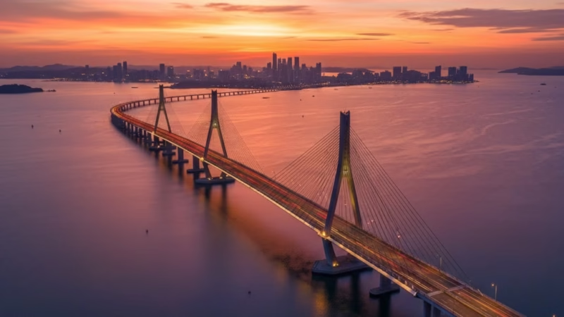
The Sultan Abdul Halim Muadzam Shah Bridge, also popularly known as the Penang Second Bridge, is Malaysia’s longest bridge and a key transport link connecting the mainland of Peninsular Malaysia with Penang Island. Stretching over 24 km, the bridge was officially opened in 2014 and is operated by the Penang Second Bridge Sdn Bhd under the Lebuhraya Butterworth–Bayan Lepas (E28) route. It plays a vital role in facilitating trade, tourism, and daily commutes between Penang and Kedah, easing traffic congestion on the older Penang Bridge and supporting Malaysia’s logistics network.
This strategic link is crucial not only for residents and local businesses but also for freight and international shipping, connecting the industrial zones on the mainland with Penang’s urban and industrial centers.
Route Overview
The Sultan Abdul Halim Muadzam Shah Bridge follows a predominantly north–south alignment, linking Batu Kawan on the mainland to Bayan Lepas on Penang Island. The bridge is part of the E28 expressway and connects seamlessly with the Butterworth–Kulim Expressway (E15) and Jalan Batu Kawan–Penang Bridge.
Along its route, travelers experience a gradual ascent onto the bridge from both sides, crossing over scenic coastal waters and navigating smooth, well-marked lanes. The main milestones along the bridge include Batu Kawan, the central marine section, and the Bayan Lepas interchange, which leads directly into Penang Island’s urban road network.
Key Cities and Exits
- Batu Kawan (Mainland Access): Entry from the Butterworth–Kulim Expressway (E15) and nearby industrial parks.
- Batu Kawan Interchange: Connects to local roads serving new townships and the Penang World City area.
- Central Bridge Section: Midpoint of the bridge offering panoramic views of the Penang Strait.
- Bayan Lepas Interchange (Island Access): Leads directly to Penang International Airport, Free Industrial Zones, and major residential areas.
The bridge has well-designed exits, providing smooth connectivity to both industrial and leisure destinations, making it convenient for daily commuters and long-distance travelers.
Scenic Highlights
The bridge is famed for its panoramic views of the Penang Strait, especially during sunrise and sunset. Travelers can enjoy:
- Sweeping coastal vistas of both mainland and island shorelines.
- Glimpses of fishing villages, mangrove forests, and small islands along the strait.
- Distant views of Penang Island’s skyline and the older Penang Bridge.
This combination of engineering marvel and natural beauty makes the bridge not only functional but also a photogenic landmark.
Rest & Service Areas (R&R)
While the bridge itself does not host full-service rest areas, nearby facilities include:
- Batu Kawan R&R: Offering petrol stations, food courts, prayer rooms, and convenience shops.
- Bayan Lepas Service Area: Close to the airport with eateries, petrol stations, and public toilets.
Travelers are advised to plan fuel and refreshment stops before entering the bridge, as the mid-span stretch is devoid of service points.
Toll Information
The Sultan Abdul Halim Muadzam Shah Bridge operates a closed toll system, with electronic collection at designated plazas. Accepted payment methods include:
- Touch ‘n Go cards
- SmartTAG devices
- RFID-enabled payments
Sample toll rates:
- Cars / Light Vehicles: MYR 7.00
- Buses / Heavy Vehicles: MYR 18.00
Tolls are regularly updated, and drivers are encouraged to check the official toll rates before travel.
Safety & Facilities
Safety is a top priority on the bridge, with measures including:
- PLUSRonda-style patrol services for emergency assistance.
- Emergency hotlines for accidents or vehicle breakdowns.
- Standard speed limits of 90 km/h across multiple lanes.
- Dedicated breakdown lanes along the bridge for stalled vehicles.
- Clear signage and lighting ensuring nighttime visibility and safety.
Useful Apps & Resources
Drivers can enhance their journey with:
- PLUS Mobile App: For toll payments and updates.
- Waze & Google Maps: Real-time traffic navigation.
- Malaysia Highway Authority website for toll updates and safety tips.
These resources help travelers plan their trips efficiently and stay informed about traffic conditions.
Travel Tips
- Best travel times: Early mornings or late evenings to avoid peak traffic.
- Driving etiquette: Maintain lane discipline, use signals when changing lanes, and observe speed limits.
- Tourist tip: Capture sunrise or sunset views from the bridge for memorable photos.
- Long-distance travel: Check toll balance and fuel levels before crossing the bridge.
Connecting Expressways
The Sultan Abdul Halim Muadzam Shah Bridge links seamlessly with:
- Butterworth–Kulim Expressway (E15)
- North–South Expressway (E1 / E2)
- Jalan Batu Kawan–Penang Bridge
This integration allows travelers to continue toward Kuala Lumpur, Ipoh, or other northern Penang destinations with ease.
Summary Table
| Feature | Details |
|---|---|
| Expressway Name | Sultan Abdul Halim Muadzam Shah Bridge |
| Code | E28 |
| Total Length | 24 km |
| Operator | Penang Second Bridge Sdn Bhd |
| Start & End Points | Batu Kawan (Mainland) – Bayan Lepas (Penang Island) |
| States Covered | Penang, Seberang Perai |
| Average Speed Limit | 90 km/h |
| Toll Type | Closed system |
Conclusion
The Sultan Abdul Halim Muadzam Shah Bridge is a vital artery in Malaysia’s transport network, enhancing connectivity between Penang Island and the mainland. It supports commerce, tourism, and daily commuting while offering scenic vistas of the Penang Strait. As a modern engineering marvel, the bridge symbolizes Malaysia’s progress in infrastructure development and continues to provide a safe, efficient, and picturesque route for travelers nationwide.
| Road Name | Road Short Name | Code | Main Route |
|---|---|---|---|
| North–South Expressway (PLUS) | North–South Expressway | PLUS / E1, E2 | Bukit Kayu Hitam – Johor Bahru |
| North–South Expressway Central Link | ELITE Expressway | E6 | Shah Alam – Nilai North |
| New Klang Valley Expressway | NKVE | E1 | Kuala Lumpur – Klang |
| Federal Highway | Federal Highway | E5 | Kuala Lumpur – Klang |
| Damansara–Puchong Expressway | LDP | E11 | Damansara – Puchong |
| Shah Alam Expressway | KESAS | E5 | Sri Petaling – Pandamaran |
| New Pantai Expressway | NPE | E10 | Subang – Bangsar |
| Maju Expressway | MEX | E20 | Kuala Lumpur – Putrajaya |
| Kajang Dispersal Link | SILK | E18 | Kajang – Semenyih |
| Kajang–Seremban Highway | LEKAS | E21 | Kajang – Seremban |
| South Klang Valley Expressway | SKVE | E26 | Pulau Indah – Kajang |
| Guthrie Corridor Expressway | GCE | E35 | Shah Alam – Rawang |
| Kuala Lumpur–Karak Expressway | KLK | E8 | Gombak – Karak |
| East Coast Expressway Phase 1 | LPT1 | E8 | Karak – Kuantan |
| East Coast Expressway Phase 2 | LPT2 | E8 | Kuantan – Kuala Nerus |
| Butterworth–Kulim Expressway | BKE | E15 | Butterworth – Kulim |
| Penang Bridge | Penang Bridge | E36 | Gelugor – Perai |
| Sultan Abdul Halim Muadzam Shah Bridge | Second Penang Bridge | E28 | Batu Maung – Batu Kawan |
| Johor Bahru Eastern Dispersal Link | EDL | E14 | Pandan – CIQ Johor |
| Senai–Desaru Expressway | SDE | E22 | Senai – Desaru |
| Second Link Expressway | Linkedua | E3 | Senai – Tuas (Singapore) |
| Kuala Lumpur–Seremban Expressway | KL–Seremban | E37 | Kuala Lumpur – Seremban |
| Cheras–Kajang Expressway | Grand Saga | E7 | Cheras – Kajang |
| Kuala Lumpur–Putrajaya Expressway | MEX | E20 | KL – Putrajaya – KLIA |
| West Coast Expressway | WCE | E32 | Taiping – Banting |
| Central Spine Road | CSR | – | Bentong – Kuala Krai |
| Federal Route 1 | Federal Route 1 | FT1 | Bukit Kayu Hitam – Johor Bahru |
| Federal Route 2 | Federal Route 2 | FT2 | Port Klang – Kuantan |
| Federal Route 3 | Federal Route 3 | FT3 | Johor Bahru – Rantau Panjang |
| Federal Route 4 | Federal Route 4 | FT4 | Gerik – Jeli |
| Federal Route 5 | Federal Route 5 | FT5 | Ipoh – Johor Bahru |
| Federal Route 8 | Federal Route 8 | FT8 | Kuala Lumpur – Kota Bharu |
| Federal Route 9 | Federal Route 9 | FT9 | Karak – Tampin |
| Federal Route 10 | Federal Route 10 | FT10 | Temerloh – Gemas |
| Federal Route 24 | Federal Route 24 | FT24 | Muar – Yong Peng |
| Federal Route 50 | Federal Route 50 | FT50 | Batu Pahat – Kluang – Jemaluang |
| Federal Route 51 | Federal Route 51 | FT51 | Melaka City – Alor Gajah |
| Federal Route 54 | Federal Route 54 | FT54 | Kuala Lumpur – Kuala Selangor |
| Federal Route 76 | Federal Route 76 | FT76 | Kuala Kangsar – Baling – Kulim |
| Federal Route 67 | Federal Route 67 | FT67 | Sungai Petani – Kuala Ketil |
| Pan Borneo Highway (Sabah) | Pan Borneo Sabah | AH150 / PBHS | Kota Kinabalu – Tawau |
| Kimanis–Keningau Highway | Kimanis–Keningau Road | – | Kimanis – Keningau |
| Kota Belud–Ranau Road | Kota Belud–Ranau | – | Coastal – Interior link |
| Pan Borneo Highway (Sarawak) | Pan Borneo Sarawak | AH150 / PBHS | Telok Melano – Miri |
| Kuching–Serian Road | Kuching–Serian | – | Kuching – Serian |
| Bintulu–Miri Coastal Road | Bintulu–Miri Coastal | – | Bintulu – Miri |
| Kota Bharu–Kuala Krai Expressway | KBKK Expressway | KBKK | Kota Bharu – Kuala Krai |
| Pan Borneo Highway (Overall) | Pan Borneo Highway | PBH | Across Sabah & Sarawak |


Comments are closed.