
Johor Bahru Eastern Dispersal Link (EDL)
Overview
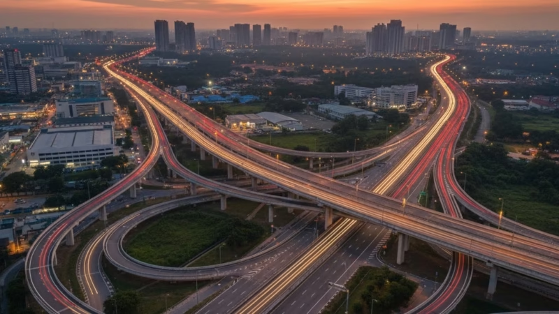
The Johor Bahru Eastern Dispersal Link (EDL) is a crucial expressway in southern Malaysia, designed to streamline traffic around Johor Bahru city and provide smooth access to the Malaysia–Singapore Causeway. Operated by Cahaya Jauhar Sdn Bhd, this expressway plays a vital role in local commuting, logistics, and international trade. It connects key urban areas with industrial zones, enhancing travel efficiency and reducing congestion near the city center and border crossings.
Route Overview
The EDL primarily runs in an east–west direction, linking the Tebrau Interchange on the North–South Expressway with the Sultan Iskandar CIQ Complex, the main border checkpoint into Singapore. Along the way, it connects to major highways and urban areas, offering a strategic route for commuters, freight transporters, and travelers heading to Singapore.
Key highlights of the route include:
- Connection to Tebrau and Johor Bahru city center
- Integration with Pasir Gudang Highway for industrial access
- Direct access to the Causeway checkpoint
Key Cities and Exits
The EDL features important interchanges that make travel convenient for both passenger vehicles and commercial transport:
- Tebrau Interchange (E2): Connects to the North–South Expressway
- Pasir Gudang Highway Junction: Gateway to industrial estates
- Johor Bahru City Exit: Access to central urban areas
- Sultan Iskandar CIQ Exit: Direct route to Singapore
These interchanges ensure smooth connectivity for commuters and freight transport alike.
Scenic Highlights
While mainly an urban expressway, the EDL offers views of the Johor Bahru skyline, industrial zones, and nearby coastal landscapes near the CIQ. Travelers can catch glimpses of the bustling city and port activity, reflecting Johor’s vibrant economy.
Rest and Service Facilities
Though relatively short, the EDL provides access to nearby rest and service areas via interchanges:
- Tebrau R&R: Food courts, petrol stations, prayer rooms, and toilets
- Pasir Gudang Industrial Stop: Convenient eateries and shops for freight drivers
These facilities make short breaks and essential stops accessible for travelers.
Toll System and Payment
The EDL uses a closed toll system, with toll rates based on distance. Accepted payment methods include:
- Touch ‘n Go
- SmartTAG
- RFID
This system ensures smooth passage for both local and international travelers, with passenger cars and heavy vehicles charged accordingly.
Safety Measures and Driving Facilities
Safety is a priority along the EDL. Features include:
- 24-hour patrols for emergency assistance
- Emergency lanes for breakdowns
- Clear signage and lane markings
- Speed limits suitable for urban expressways
- Emergency hotlines for instant support
These measures create a safe and reliable driving environment for everyone on the road.
Useful Apps and Resources
Travelers can make use of apps and tools to enhance their journey:
- PLUS Mobile App: Real-time traffic updates
- MyEG: Toll and transport inquiries
- Google Maps / Waze: Live navigation and route planning
These tools help avoid congestion and plan the most efficient route.
Travel Tips for Johor Bahru EDL
- Plan ahead during peak hours, especially near the CIQ
- Ensure sufficient toll credit to avoid delays
- Follow traffic rules and be mindful of sudden urban slowdowns
- Ideal for both commuters and tourists heading to Singapore
Connecting Expressways
The EDL links seamlessly with other major routes, enhancing regional connectivity:
- North–South Expressway (E2) via Tebrau Interchange
- Pasir Gudang Highway (JPP) for industrial access
- Causeway Link Roads for direct Singapore travel
This integration makes the EDL a strategic corridor in southern Malaysia’s transport network.
Summary Table
| Feature | Details |
|---|---|
| Expressway Name | Johor Bahru Eastern Dispersal Link |
| Code | EDL |
| Operator | Cahaya Jauhar Sdn Bhd |
| Start Point | Tebrau Interchange (E2) |
| End Point | Sultan Iskandar CIQ Complex |
| States Covered | Johor |
| Average Speed Limit | 90 km/h |
| Toll Type | Closed System |
Conclusion
The Johor Bahru Eastern Dispersal Link is more than just a road—it’s a vital transportation artery that supports commuting, logistics, and international trade with Singapore. By reducing congestion, improving access, and connecting key urban and industrial zones, the EDL plays a critical role in Johor’s economic development and enhances travel efficiency for both locals and visitors.
| Road Name | Road Short Name | Code | Main Route |
|---|---|---|---|
| North–South Expressway (PLUS) | North–South Expressway | PLUS / E1, E2 | Bukit Kayu Hitam – Johor Bahru |
| North–South Expressway Central Link | ELITE Expressway | E6 | Shah Alam – Nilai North |
| New Klang Valley Expressway | NKVE | E1 | Kuala Lumpur – Klang |
| Federal Highway | Federal Highway | E5 | Kuala Lumpur – Klang |
| Damansara–Puchong Expressway | LDP | E11 | Damansara – Puchong |
| Shah Alam Expressway | KESAS | E5 | Sri Petaling – Pandamaran |
| New Pantai Expressway | NPE | E10 | Subang – Bangsar |
| Maju Expressway | MEX | E20 | Kuala Lumpur – Putrajaya |
| Kajang Dispersal Link | SILK | E18 | Kajang – Semenyih |
| Kajang–Seremban Highway | LEKAS | E21 | Kajang – Seremban |
| South Klang Valley Expressway | SKVE | E26 | Pulau Indah – Kajang |
| Guthrie Corridor Expressway | GCE | E35 | Shah Alam – Rawang |
| Kuala Lumpur–Karak Expressway | KLK | E8 | Gombak – Karak |
| East Coast Expressway Phase 1 | LPT1 | E8 | Karak – Kuantan |
| East Coast Expressway Phase 2 | LPT2 | E8 | Kuantan – Kuala Nerus |
| Butterworth–Kulim Expressway | BKE | E15 | Butterworth – Kulim |
| Penang Bridge | Penang Bridge | E36 | Gelugor – Perai |
| Sultan Abdul Halim Muadzam Shah Bridge | Second Penang Bridge | E28 | Batu Maung – Batu Kawan |
| Johor Bahru Eastern Dispersal Link | EDL | E14 | Pandan – CIQ Johor |
| Senai–Desaru Expressway | SDE | E22 | Senai – Desaru |
| Second Link Expressway | Linkedua | E3 | Senai – Tuas (Singapore) |
| Kuala Lumpur–Seremban Expressway | KL–Seremban | E37 | Kuala Lumpur – Seremban |
| Cheras–Kajang Expressway | Grand Saga | E7 | Cheras – Kajang |
| Kuala Lumpur–Putrajaya Expressway | MEX | E20 | KL – Putrajaya – KLIA |
| West Coast Expressway | WCE | E32 | Taiping – Banting |
| Central Spine Road | CSR | – | Bentong – Kuala Krai |
| Federal Route 1 | Federal Route 1 | FT1 | Bukit Kayu Hitam – Johor Bahru |
| Federal Route 2 | Federal Route 2 | FT2 | Port Klang – Kuantan |
| Federal Route 3 | Federal Route 3 | FT3 | Johor Bahru – Rantau Panjang |
| Federal Route 4 | Federal Route 4 | FT4 | Gerik – Jeli |
| Federal Route 5 | Federal Route 5 | FT5 | Ipoh – Johor Bahru |
| Federal Route 8 | Federal Route 8 | FT8 | Kuala Lumpur – Kota Bharu |
| Federal Route 9 | Federal Route 9 | FT9 | Karak – Tampin |
| Federal Route 10 | Federal Route 10 | FT10 | Temerloh – Gemas |
| Federal Route 24 | Federal Route 24 | FT24 | Muar – Yong Peng |
| Federal Route 50 | Federal Route 50 | FT50 | Batu Pahat – Kluang – Jemaluang |
| Federal Route 51 | Federal Route 51 | FT51 | Melaka City – Alor Gajah |
| Federal Route 54 | Federal Route 54 | FT54 | Kuala Lumpur – Kuala Selangor |
| Federal Route 76 | Federal Route 76 | FT76 | Kuala Kangsar – Baling – Kulim |
| Federal Route 67 | Federal Route 67 | FT67 | Sungai Petani – Kuala Ketil |
| Pan Borneo Highway (Sabah) | Pan Borneo Sabah | AH150 / PBHS | Kota Kinabalu – Tawau |
| Kimanis–Keningau Highway | Kimanis–Keningau Road | – | Kimanis – Keningau |
| Kota Belud–Ranau Road | Kota Belud–Ranau | – | Coastal – Interior link |
| Pan Borneo Highway (Sarawak) | Pan Borneo Sarawak | AH150 / PBHS | Telok Melano – Miri |
| Kuching–Serian Road | Kuching–Serian | – | Kuching – Serian |
| Bintulu–Miri Coastal Road | Bintulu–Miri Coastal | – | Bintulu – Miri |
| Kota Bharu–Kuala Krai Expressway | KBKK Expressway | KBKK | Kota Bharu – Kuala Krai |
| Pan Borneo Highway (Overall) | Pan Borneo Highway | PBH | Across Sabah & Sarawak |


Comments are closed.